
Geologists at Moscow State University Lomonosov University (Moscow State University) presented the results of a study of 150 million years of Arctic history, according to which the Mendeleev Ridge (scientists call it the Mendeleev Rise) is an underwater part of the Eurasian continental shelf. This was reported in the journal Earth-Science Reviews.
Scientists conducted seismic studies of the Arctic region and compared the data with the results of the analysis of rock samples obtained from a well on the Lomonosov Ridge and from the slopes of the Mendeleev Ridge. According to the results of the study, the scientists compiled a paleogeographic and paleotectonic atlas. The maps presented in it reflect the tectonic changes that have occurred in the Arctic Ocean from the Jurassic to the present. In particular, geologists have proven that the Mendeleev Ridge has a continental foundation.
“We proved that the Mendeleev Rise began to form as a rift system about 125 million years ago. We propose to classify it as an interrupted volcanic passive continental margin. This means that it is a continuation of our continent, ”said the author of the study, professor of the geological faculty of Moscow State University Anatoly Nikishin, RT.
The official adoption of this conclusion is important not only for science, but may also affect the change in the political map of the world, the researchers believe. Back in 2001, Russia submitted an official submission to the UN Commission on the Limits of the Continental Shelf, in which it claimed to be vast Arctic territories beyond the 200-mile zone.
The UN Commission rejected this request, requesting additional scientific justification. In 2007, a Russian polar expedition led by researcher Arthur Chilingarov took place, which was to prove that the underwater ridges of Lomonosov and Mendeleev are a continuation of the Russian continental shelf. As a result of the immersion of two bathyscaphes on the bottom of the Arctic Ocean and other studies, new data were obtained, and a Russian flag made of titanium was installed on the seabed.
- In 2007, the Russian flag made of titanium was installed on the seabed
- © RT
In 2015, the United Nations Commission on the Limits of the Continental Shelf submitted a new version of the application for the annexation of the Lomonosov Ridge and other sections of the seabed, including the Podvodnikov Basin, the Mendeleev Ridge, the southern tip of the Gakkel Ridge and the North Pole zone. In total, it covered 1.2 million square meters. km of the continental shelf in the Arctic and contained a huge array of scientific data collected by scientists for more than 10 years.
The results obtained by the Chilingarov expedition and other researchers were presented, including the analysis of samples of Arctic rocks that were raised in 2012 from a depth of more than 2.5 thousand meters. However, to date, a decision to expand the Russian Arctic territories at the UN has not yet been made.
Another attempt to prove Russia's right to own Arctic territories beyond the 200-mile zone will be supplemented by new data obtained by Professor Nikishin and his colleagues.
In an interview with RT, Nikishin, who is also a scientific expert of the special group of the Ministry of Natural Resources of Russia, said that the results of the work of MSU scientists are currently used by the Ministry for working discussions in the UN Commission on the external borders of the shelves regarding the Russian application.
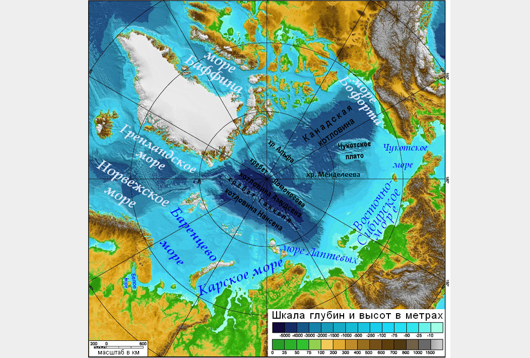
- The relief of the bottom of the Arctic Ocean
- © Wikimedia Commons
The new data obtained will help Russia create a scientific justification for the external borders of the Arctic shelves and help coordinate it with the United States, Canada and Denmark, the scientist noted.
“The publication of our long article on the geological history of the Arctic in one of the best scientific journals in the world shows that our concept is well founded. It can significantly contribute to the passage of the Russian application to the UN, as one of the main criteria is the justification adopted by the community of internationally recognized experts in Earth sciences, ”the source told RT.
“It is important that the concepts of the geological history of the Arctic, presented by different Arctic countries, are mutually linked, only under this condition can we expect a constructive decision by the UN commission,” summed up Professor Nikishin.