
Share
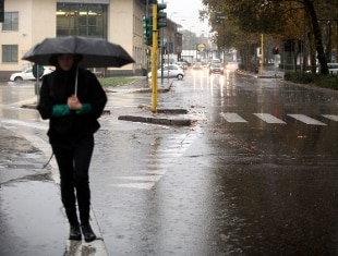
02 August 2020 Over the next few hours, a rift or an atmospheric pressure of North Atlantic origin with axis currently on France, will make its decisive entry into our country. The sharp deterioration in weather conditions bring on all the northern regions, frequent and intense rainfall, prevailing character backhand or temporal extension, tomorrow in the peninsular center, also locally heavy, especially on pre-Alps and the North East.The notice issued by the Civil Protectionfrom tomorrow morning, Monday 3 August, forecasts the persistent rainfall from scattered to widespread and prevalently stormy, over Piedmont, Lombardy, Emilia-Romagna, Veneto, Friuli Venezia Giulia and the Autonomous Province of Trento, with the extension of the phenomenology to Liguria and Tuscany. The phenomena will be accompanied by heavy showers, frequent electrical activity, hailstorms and strong gusts of wind.
On the basis of current and expected phenomena, an orange alert was assessed for tomorrow, Monday 3 August, over most of Lombardy and Emilia-Romagna . A yellow alert was also assessed on the remaining sectors of Emilia and Lombardy, on the whole territory of Liguria, Piedmont, Friuli Venezia Giulia, Veneto, Umbria, Marche and on part of Trentino Alto Adige and Tuscany.
Temperatures in sharp decline, maxima between 27 and 31. In the center it worsens during the day with scattered thunderstorms starting from upper Tuscany towards Umbria and the internal Marches. Decreasing temperatures, maximum between 31 and 35. In the South still dominant anticyclone with a prevalence of clear or slightly cloudy skies in all sectors. Mainly stationary temperatures, maximum between 32 and 36.
From Tuesday it improves in the Northwest with large clearings from the West, unstable on Triveneto and Emilia Romagna with thunderstorms running out, except on Romagna. Decreasing temperatures, maximum between 24 and 29. In the center, unstable between Tuscany and Marche with showers and thunderstorms, local phenomena from the afternoon on the remaining peninsulars. Decreasing temperatures, maximum between 28 and 33.
Also in the South scattered and lightened clouds with local rainfall between Campania, Basilicata and Puglia; sunniest in Sicily. Decreasing temperatures, maxima between 30 and 35.
From Wednesday slightly rising temperatures, maxima between 26 and 31. In the Center, often unstable on the Adriatic with showers and thunderstorms decreasing from the North; diurnal phenomena also on Lazio.
The meteorological and critical situation forecast for Italy is updated daily on the basis of new forecasts and the evolution of phenomena, and is available on the website of the Department of Civil Protection (www.protezionecivile.gov.it), together with the general rules of behavior to be followed in bad weather.
Information on regional alert levels and weather phenomena, on specific critical issues that could affect regional territories such as hydrogeological and hydraulic problems, and all prevention actions are managed by the territorial structures of civil protection, in contact with which the Department will follow the evolution of the situation.