
China News Service, July 12th: According to the Central Meteorological Observatory website, from July 8th to August 13th, eastern Shandong, northern Jiangsu, northern and western Anhui, southern Henan, eastern and southwestern Hubei, Chongqing and western Guizhou There are heavy rains (50-80 mm) in parts of the north, central and eastern Yunnan, northwestern Guangxi, and northern Hebei.
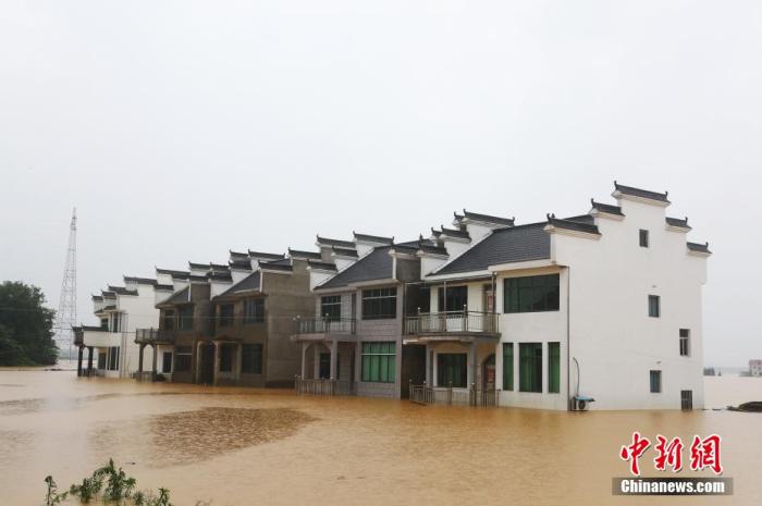
On July 10, in Wuhan, Hubei, citizens swam past the flooded Huanghuaji Hydrophilic Platform. Affected by the recent heavy rainfall, the water level of the main stream in the middle and lower reaches of the Yangtze River and the control stations of the two lakes continued to rise, exceeding the warning water level. China News Service reporter Zhang Changshe
Heavy rainstorms in Anhui, Henan and other places
Yesterday, heavy rain or heavy rain occurred in parts of northern and southeastern Chongqing, northwestern Guizhou, northeastern Guangxi, northeastern and southwestern Hubei, central and northern Anhui, central and northern Jiangsu and southeastern Shandong, eastern and southern Henan, Zhumadian, Henan The local rainfall in Fuyang, Anhui is 150-220 mm; in parts of central Inner Mongolia, eastern Gansu, central and southern Shaanxi, southwestern Shanxi, southern Jilin, northeastern Liaoning, central and southern Hebei, and southern Beijing, heavy rains occurred.
Heavy rains in Jianghan, Huanghuai and other places in the east of the Southwest
From 08:00 on July 12 to 08:00 on 13th, eastern Shandong, northern Jiangsu, northern and western Anhui, southern Henan, eastern and southwestern Hubei, Chongqing, western and northern Guizhou, central and eastern Yunnan, northwestern Guangxi, northern Hebei and other places Some areas have heavy to heavy rains (50-80 mm); some of these areas are accompanied by short-term heavy precipitation (maximum hourly rainfall of 20-40 mm, local can exceed 50 mm), and local areas have strong convective weather such as thunderstorms and strong winds . As the range of heavy precipitation decreased and the intensity weakened, the Central Meteorological Observatory lifted the rainstorm blue warning at 06:00 on July 12.
At the site of the flood dike in Weihe, Poyang County, Jiangxi Province. Photo by Liu Zhankun
In addition, due to the impact of cyclones entering the sea, on the 12th day to night, most of the Yellow Sea will have winds of 7 to 8 and gusts of 9 to 10, and there will be southerly winds of 7 and 8 in the north of the East China Sea; 13 From day to night, most of the Yellow Sea will have winds of 7 to 8 and gusts of 9 to 10, and there will be southwest winds of 7 and gusts of 8 in the northeast of the East China Sea. The Central Meteorological Observatory continued to publish forecasts of strong sea winds at 06:00 on July 12.
From the 13th to the 16th, there will be a heavy rainfall process in the eastern part of the southwestern region, Jianghan, Jianghuai, and northern Jiangnan. There will be heavy rain in some of the above areas, and local heavy rain.
Heavy rain or thunderstorms in North China
In the next three days, there will be multiple showers or thunderstorms in North China. The rainfall is unevenly distributed, and there are heavy rains or torrential rains, accompanied by strong convective weather such as short-term heavy precipitation, thunderstorms, strong winds, and hail.