
- Bad weather, storm in Milan: Seveso overflows, inconveniences and blackouts
Share
04 June 2020Summer is still long. Bad weather continues with the arrival of a disturbance that is bringing rain, thunderstorms and in some cases storms first in the North (with a drop in temperatures of up to 10 degrees) and tomorrow also in the Center South.On Saturday there should be a temporary improvement, on Sunday rains are expected in the Centronord and in Sardinia. Meanwhile, Bergamo is one of the areas with agriculture most affected by bad weather and hail.
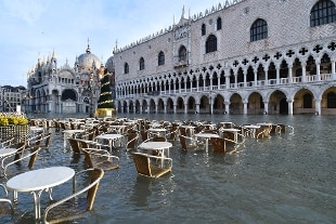
In Venice tonight the high water with 120 centimeters returns
High water returns to Venice: for this evening at 10.30 pm, the Municipality's tidal center has a maximum of 120 centimeters. The passage of a rapid, but profound perturbation of a late spring nature will have its effects on the sea level coinciding with the maximum of the astronomical tide. Levels are abnormal for the period. The inhabitants of Venice are invited to follow the forecast update bulletins. The levels, if confirmed, would cause the total flooding of San Marco square and also of some shops.
Rain and hail
In the coming days a cyclonic vortex descending from Northern Europe will send a series of perturbed fronts that will insert Italy into a long period of instability. The most intense bad weather is expected by tomorrow evening. Showers, thunderstorms and hailstorms (also of considerable size) will rage above all on central-eastern Liguria, Lombardy and Triveneto. Storms are also expected on these regions. By this evening the bad weather will take over Tuscany and in the night it will fall on Lazio, Campania and the rest of the South. Tomorrow the disturbance will discharge its quantity of rain on Lazio, Campania, Calabria and Basilicata; also in these regions the precipitations can take on a cloudburst, as in Rome and Naples.
Unstable weekend
The weather will be unstable even on the weekend. On Saturday and Sunday other unstable fronts will point to the northern regions with thunderstorms that will break out especially during the afternoon and pre-evening hours. In the Center-South, on the other hand, the increase in pressure will guarantee two sunnier days. Throughout this phase the temperatures will be decidedly cooler where it will be rainy (maximum values below 20 C) and mild where there will be more sun (maximum values not higher than 23-25 C).
In Genoa whirlwind unveils shed
A whirlwind has uncovered the roof of a shed of a commercial activity last night in Genoa Voltri, in via Don Giovanni Verità. There are no wounded. Multedo firefighters intervened on the site, who made the building safe and prevented the material from being dispersed on the street. Bad weather, which has been hitting Genoa last night, has caused the flooding of a house in via Novella, at Cep. Since yesterday, rains have affected almost all the regional territory.
Floods and fallen trees in Turin
Thirty operations were carried out in just over an hour by the firefighters in Turin for the violent downpour that broke out in the late yesterday afternoon on the city. No serious damage was reported: requests in the city mainly concerned fallen trees or branches and flooding of cellars and garages. The South belt is particularly interested, in particular Beinasco and Nichelino. Arpa Piemonte has declared the yellow alert for hydrogeological risk, connected to thunderstorms: tomorrow "widespread bad weather is expected, with thunderstorms also persistent and organized, especially on the northern part of the region. The most intense moment is expected between the morning and the afternoon with possible hailstorms and intense gusts of wind ".