
- Egypt: Spanish archaeologists discover three pharaonic tombs devoid of luxuries
- Arctic: giant crater discovered under Greenland ice
- Archeology: the discovery of the largest Mayan site reveals a society without hierarchies
In many places in Italy, any work has the possibility of encountering archaeological remains from its glorious past that have been buried over the centuries. Much of the legacy of Ancient Rome will never be recovered, either because they are too large sites or because they have been trapped in the midst of modern buildings and infrastructure. However, thanks to radar technology, staying underground is no longer an obstacle to studying these archaeological treasures in depth . The ancient city of Falerii Novi is a good example.
Archaeologists already knew this ancient enclave located about 50 kilometers north of Rome because it preserved its walls and had not been built on top of its ruins, but now they have been able to know in depth what it was like without the need for any excavation. A team of researchers from Cambridge University and Ghent University have for the first time drawn the complete map of a Roman city using exclusively advanced ground penetrating radar (GPR) that has shown them amazing details that were underground. This technology allows them to look at what is at different depths, so they can study the evolution of a settlement over the centuries.
Thus, they have located a spa complex, a market, a temple, a type of monument different from what they had seen until now and the extensive network of water pipes in this city that was half as large as Pompeii, the town buried by the ashes and stones of Vesuvius in AD 79 Falerii Novi had a longer life. Archaeologists believe that it was first occupied around 241 BC and survived into the Middle Ages (around 700).
"The city was abandoned in the early Middle Ages, after the decline of Roman power and the gradual loss of population," explains Martin Millet, the Cambridge University researcher who leads this study, published this week in Antiquity magazine . In its period of splendor, he adds, "it probably had around 3,000 inhabitants , but our analysis may clarify this in the future."
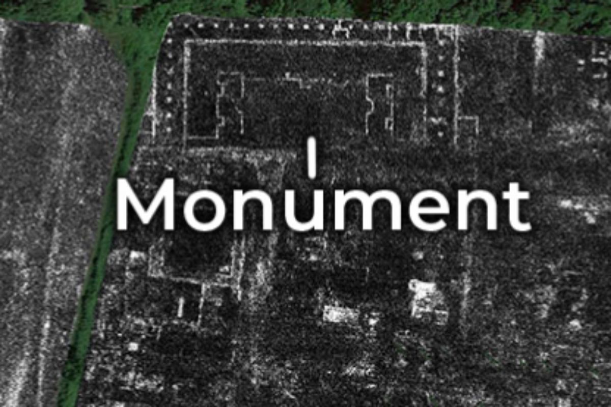
A typical Roman city
Falerii Novi, says Martin Millet, was a typical city of the Roman Empire, and precisely therein lies, from his point of view, its value: "It is an example of a fairly ordinary Roman city," says the archaeologist, who has been working on this project since 2015. His goal, he explains, is "to offer as much Falerii Novi information as possible without digging."
Yes they have found some peculiarities. For example, the design of Falerii Novi was less standardized than many other well-studied cities , such as Pompeii. The temple, the market building, and the uncovered bath complex feature more complex architecture than would be expected in a small town like this.
In a southern district, just inside the city walls, radar showed a large rectangular building connected to a series of water pipes leading to the aqueduct. Surprisingly, these pipes can be traced through much of Falerii Novi. The team believes that this structure was a swimming pool or outdoor pool, which is part of a major complex of public baths.
They were more surprised to identify near the north gate of the city a pair of large structures facing each other within a duplex porticus (a passageway covered with a central row of columns). They do not know any direct parallelism, but their hypothesis is that they were part of an impressive public monument .
After being abandoned, the ruins of Falerii Novi were gradually covered with vegetation and different material until it was buried in the following centuries. Now, with the GPR, they are studying the changes that the buried city experienced; for example, they have found evidence that stones were stolen.
GPR radar
Regarding GPR radar technology, Millet points out that it has been used in archeology for more than 20 years: "The fundamental difference is the intensity of the samplings, with readings every 6.5 centimeters throughout the city that they deliver incredibly high resolution images of what is buried . This is possible using multiple antennas, high-precision surveying and smart computing. "
The equipment is installed in a land vehicle, similar to a quad , which has been sweeping the 30.5 hectares that this ancient Roman enclave occupied. "The radar antenna sends a pulsed radio signal to the ground and listens to the echoes. The echoes are proportional to the depth, so the software can map what's at different depths through the ground," explains Millet, who previously he had used this technology to map the Roman colony Interamna Lirenas, in central Italy, and on a smaller scale, Aldborough, in North Yorkshire, England.
As the authors note, "this technology could revolutionize our knowledge of ancient settlements." Millet believes that with the help of the GRP they could cover larger ancient cities, such as Miletus in Turkey, Nicopolis in Greece or Cyrene in Libya because "we still have a lot to learn about the urban life of the Romans."
In accordance with the criteria of The Trust Project
Know more- Science and health
- science
- Graphics
EnvironmentSpanish recycled 8% more packaging in 2019
NASA and SpaceX open a new space age by launching the private Crew Dragon spacecraft with astronauts
ExplorationUSA has its own ship again: This is the space taxi that SpaceX has built for NASA
See links of interest
- News
- Translator
- Programming
- Calendar
- Horoscope
- Classification
- League calendar
- Films
- Schools
- Masters
- Cut notes
- Rich
- Universities
- Themes
- Pau Dones